Weather on Sunday 25 October: very wet night, then sunshine returns

The night from Saturday to Sunday promises to be very wet across Belgium, with heavy rain over the whole country and strong winds of 70 to 80 km/h. But this Sunday 25 October, the sun returns from the morning in the north and takes over in the afternoon on the plains, under sustained westerly winds. It will be 9 to 14°C. And don't forget: tonight we change to winter time.
- Tonight: heavy rain everywhere, heaviest between 23:00 and 04:00; gusts of 70 to 80 km/h, up to 85 km/h at the coast
- Morning: sunshine returns in the north and centre, rain lingers in the south until mid-morning
- Afternoon: fine sunny spells in the lowlands, 9 to 14°C, westerly wind of 55 to 65 km/h
- Rainfall totals: 11 to 25 mm in the lowlands, up to 35 mm over the southern uplands
- Winter time: tonight at 03:00, it will become 02:00
Météo Belge's yellow weather warning for rain remains active across the whole country until Sunday at 08:00, 10:00 for the provinces of Namur, Liège and Luxembourg. The yellow weather warning for wind runs until Sunday morning, and until 19:00 at the coast. Luxembourg province is not affected by the wind weather warning. Check the weather warning for your town
🌧️☀️ Sunday 25 October: very wet night, then sunshine returns
🌙 Tonight: heavy rain and strong wind
Rain will set in everywhere during the evening and become heavy overnight, locally intense over the coast and the Ardennes peaks. It will be strongest between 23:00 and 04:00. Wind will gust at 70 to 80 km/h inland and up to 85 km/h on the coast. This windy spell is linked to depression Boelo, which passes north of the British Isles: nothing to do with Austen, there is no storm affecting us. The air will remain mild in the plains, around 10 to 12°C, and cooler on the eastern plateaus (6 to 8°C).
🌤️ Sunday morning: sunshine returns from the north
Rain will clear from west to east (approximate times):
- Coast: around 05:00
- Flanders, Brussels and Antwerp: around 06:00-07:00
- Hainaut, Namur, Liège and Limburg: around 07:00-08:00
- Ardennes: around 09:00-10:00
- Gaume: late morning
The sun returns very early on the coast, in Flanders and in the centre. Further south, the sky remains overcast for longer, with fog and low cloud over the high ground. The wind remains noticeable, especially on the coast.
☀️ Sunday afternoon: fine clear spells in the lowlands
In the lowlands, clear spells will dominate clearly, under a moderate to sometimes fairly strong westerly wind: 55 to 65 km/h inland, 80 to 85 km/h on the coast. The Ardennes plateau and Gaume keep a more overcast sky, with the occasional drop of rain. An isolated shower remains possible over the Campine. It will be 13 to 14°C in the lowlands, 9 to 12°C over the Ardennes.
🌙 Sunday evening: clear sky and wind easing
No more rain falls and the night looks set to be clear over most of the lowlands. Only the Ardennes summits keep their low cloud, and Gaume clouds over again before midnight. The gusts lose their strength, except along the coast where the wind remains fairly strong into the evening.
💧 How much rain?
Between Saturday evening and Sunday morning, we expect 11 to 25 mm in lowland areas and up to 35 mm on the high ground in the south, from Gaume to the High Fens. With soils already saturated after Austen, puddles and surface runoff are possible. These totals are approximate.
🌡️ Forecast temperatures Sunday in the main towns
| Town | Minimum | Maximum | Afternoon sky | Gusts (day) | Rain (night + day) |
| Brussels | 11°C | 14°C | Partly cloudy | 65 km/h | 15 mm |
| Antwerp | 11°C | 13°C | Cloudy and sunny | 65 km/h | 14 mm |
| Ghent | 11°C | 14°C | Partly cloudy | 65 km/h | 14 mm |
| Ostend | 12°C | 14°C | Partly cloudy | 85 km/h | 20 mm |
| Liège | 10°C | 14°C | Partly cloudy | 65 km/h | 20 mm |
| Namur | 10°C | 14°C | Partly cloudy | 65 km/h | 21 mm |
| Charleroi | 10°C | 14°C | Partly cloudy | 65 km/h | 20 mm |
| Mons | 11°C | 14°C | Partly cloudy | 65 km/h | 14 mm |
| Tournai | 11°C | 14°C | Sunny | 65 km/h | 12 mm |
| Hasselt | 10°C | 14°C | Partly cloudy | 70 km/h | 17 mm |
| Marche-en-Famenne | 9°C | 13°C | Sunny | 60 km/h | 25 mm |
| Virton | 9°C | 12°C | Cloudy and sunny | 75 km/h | 36 mm |
| Butgenbach | 6°C | 9°C | Partly cloudy | 65 km/h | 35 mm |
📅 What's next? A calm Monday, a very mild Tuesday, then sunshine
Monday 26 October: grey and calm
The weather stays dry overnight, then cloud will dominate. A few light showers will reach the coast and Westhoek in the afternoon, with scattered drops elsewhere. Temperatures will be 8 to 12°C, and frankly chilly on the ridges of the east early in the morning.
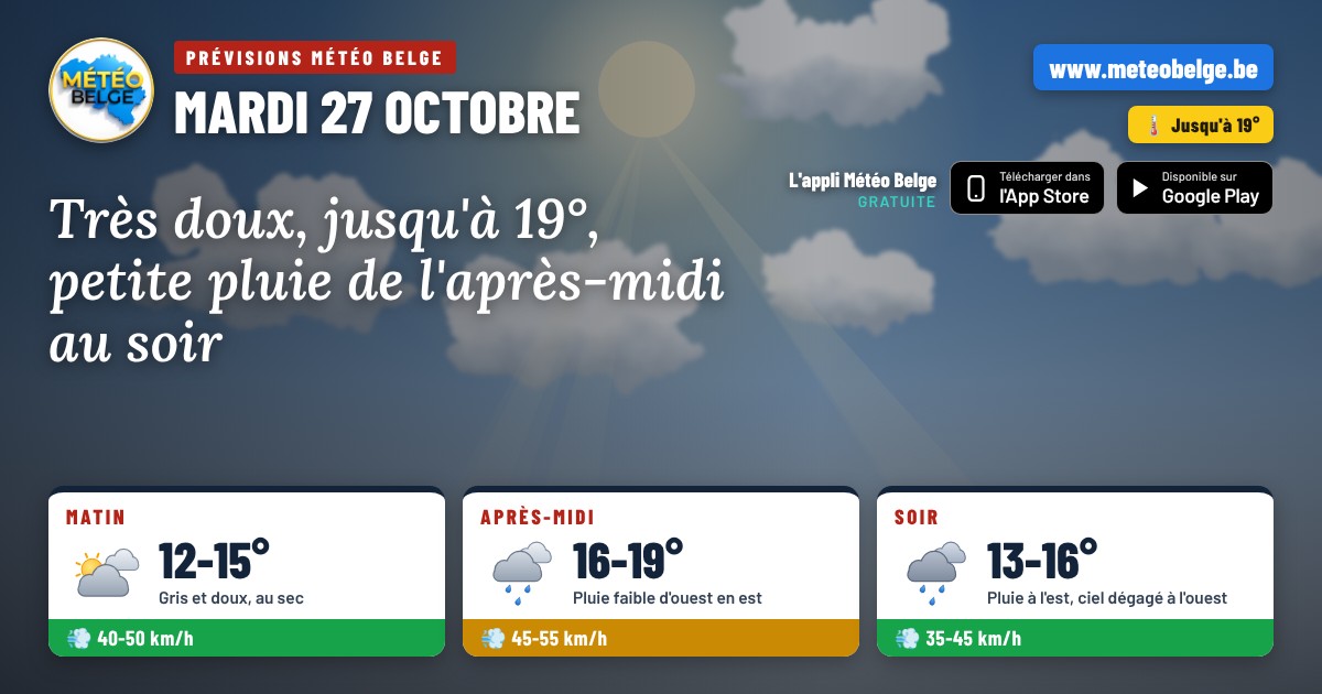
Tuesday 27 October: remarkable mildness
Under a noticeable south-westerly wind, mildness would be well marked for the season, with 14 to 18°C in the afternoon. Light showers would remain possible late in the afternoon from Flanders to Hainaut and over central areas.
Wednesday 28 October: bright sunshine
Pressure would rise noticeably and bright sunshine would prevail almost everywhere, in fresh and dry air in the morning. The day would be completely dry, with 10 to 15°C in the afternoon.
| Day | Weather | Temperatures (min / max) | Wind |
| Monday 26 | ☁️ Grey and calm, a few drops in the west | 4 to 8°C / 8 to 12°C | South, gusts of 40 to 55 km/h |
| Tuesday 27 | 🌡️ Very mild, light showers in the afternoon | 8 to 14°C / 14 to 18°C | South-west, gusts of 50 to 65 km/h |
| Wednesday 28 | ☀️ Plenty of sunshine, dry weather | 5 to 10°C / 10 to 15°C | South-west, gusts of 30 to 45 km/h |
- Remember to put your clocks back one hour: at 03:00, it will be 02:00
- Sunday morning, still avoid woodlands and forest paths: weakened branches could fall
- Be careful on the road when you wake up: puddles and branches on the ground
- Make the most of the sunny afternoon to get out, with a jacket, as the wind will remain strong
Reliability is good for Sunday: forecasts agree on heavy rain overnight and sunshine returning in the afternoon. Exact amounts may vary by a few millimetres from one town to another, especially over higher ground. For Tuesday, mild conditions are confirmed, and the return of dry, sunny weather on Wednesday remains to be confirmed.
❓ Frequently asked questions
What will the weather be like in Belgium this Sunday 25 October?
After a night of heavy rain, the sun returns on Sunday morning in the north and takes over in the afternoon in the lowlands. Rain lingers until late morning in the south. Temperatures range from 9 to 14°C, with strong westerly winds.
How much rain will fall tonight?
We're expecting 11 to 25 mm in the lowlands and up to 35 mm over the higher ground in the south, from Gaume to the High Fens, between Saturday evening and Sunday morning.
When do we switch to winter time?
Tonight, from Saturday to Sunday 25 October: at 03:00, it will become 02:00. You'll gain an hour of sleep.
What will the weather be like next week?
Monday will be grey and calm, Tuesday very mild with temperatures up to 18°C, then Wednesday looks to be sunny and dry.
Forecast prepared by Michaël Vincent — Météo Belge.