Weather forecast for Tuesday 10 November: rime frost fog at dawn, then rain returns from the south
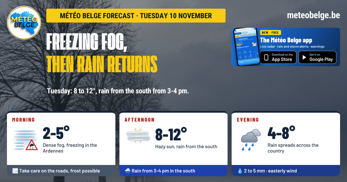
This Tuesday 10 November will start off cold and misty: dense fog, sometimes freezing in the Ardennes and in valleys, and frost at the bottom of the East Cantons valleys. The sun will then break through, but increasingly veiled, before rain returns from the south from 15:00-16:00 onwards, then across the whole country in the evening. Temperatures will reach 8 to 12°C. Wednesday looks set to be rainy but very mild.
- Night: dense fog in Entre-Sambre-et-Meuse, sometimes icy in the Ardennes and in valleys, down to -5°C in the valleys of the Eastern Cantons
- Morning: greyness in the north, persistent fog in Entre-Sambre-et-Meuse, frost possible, 2 to 5°C
- Afternoon: increasingly pale sunshine, light rain from the south from 15:00-16:00, 8 to 12°C
- Evening: rain spreads across the country, more steady in Flanders
- Rain: 2 to 5 mm over the day
- Wind: from the east, gusts of 20 to 35 km/h
🌫️ This Monday: persistent fog before the sunshine
A cotton wool morning on Monday: the fog proved very persistent. In Ostend, visibility fell to 200 metres and only really improved late in the morning. It was around 400 metres around Brussels and Antwerp. Once this curtain lifted, the sky cleared nicely over much of the country, with 8 to 10°C in the afternoon in Ostend, Antwerp, Brussels, Charleroi and Liège. Further south, in Luxembourg province, grey skies had the final say.
🌧️ Tuesday 10 November: freezing fog, then rain returns
🌌 Tonight: dense fog and ground frost in valleys
One dull and damp will reach the north of the country, with mist and patchy fog in the Campine and Flemish Brabant. In theEntre-Sambre-et-Meusethe fog will set in from the start of the night and could become densePatches of mist will also form in the hollows of the Famenne. Over thethe Ardennes et dans les valleys, this fog may be freezing Mind the slippery roads. Under still clear skies, a hard frost will occur deep in the valleys of the East Cantons. A little drizzle remains possible in Gaume. Minimums of -4 à -5°C in the valleys of the Eastern Cantons, -1°C in the Famenne, 0°C in the Botte du Hainaut, the Namur region, the Liège region and the Mons region, 1°C in the centre of the country, in Flanders and in Limburg, 2°C in the Antwerp region and on the coast, 5°C In Gaume, under the clouds.
🌅 Tuesday morning: persistent fog and possible frost
Mist and overcast skies will remain well entrenched from the coast to the Campine and will only clear slowly. In Entre-Sambre-et-Meuse, fog will persist until late morning: caution on the roads. A few patches will linger over Hainaut and the Namur region. Eastern Wallonia and the Ardennes will enjoy more sunshine, though veiled, with possible frost at dawn in the valleys of the Eastern Cantons. Where fog lingers over the Ardennes and in the valleys, it will remain frosty early in the morning. Gaume will keep grey skies. At sunrise: 2°C in Entre-Sambre-et-Meuse, the Namur region, in Famenne and over the High Fens, 3°C in Hainaut, the centre, in Flanders, in the Liège region and at the coast, 4°C in Limburg, 5°C in Gaume.
🌥️ Tuesday afternoon: veiled sunshine, rain from the south
I'm ready to translate French text to British English for Météo Belge. Please provide the French text you'd like me to translate. high clouds will thicken gradually, and the sun will become increasingly pale where it shines. Light rain will arrive from the south from 15:00-16:00from Gaume to Entre-Sambre-et-Meuse via the Ardennes, then moving to western Hainaut, the centre of the country and interior West Flanders just before nightfall. The coast, the Campine and the Herve Plateau will remain dry until the evening. It will 8°C along the coast, in Gaume and on the High Fens, 9°C in Flanders, in Brussels, in Picardy Wallonia and in the Antwerp region, 10°C in Hainaut, Charleroi, Famenne and Limburg, 11°C in the Namur region, up to 12°C in the Liège region. UV index: 2, low.
🌧️ Tuesday evening: rain spreads across the whole country
Rain will reach the whole country in the early evening, first via Hainaut and West Flanders, then to the province of Liège and Limburg around 20:00. It will mostly remain light, but more persistent in Flanders. Over the Ardennes, the landscape will disappear into cloud and patches of fog will reduce visibility. Accumulations of 2 to 5 mm over the day. Temperatures will remain almost stable until midnight: 4°C on the High Fens, 6°C on the coast, in East Flanders, the Antwerp region and Limburg, 7°C in Brussels, Picardy Wallonia and Gaume, 8°C in Hainaut, Entre-Sambre-et-Meuse, the Namur region, the Liège area and Famenne.
💨 The wind
The wind will blow from the east, with gusts of 20 to 35 km/h, strongest near the coast.
Le freezing fog forms when the air temperature is below zeroThe water droplets in the fog remain liquid in the air, but they freeze instantly in contact with cold surfaces: roads, windscreens, branches, fences. They deposit a thin layer of ice on them, sometimes invisible, which makes the road slipperyThis is what could happen on Tuesday morning in the Ardennes and in the valleys.
🌡️ Expected temperatures on Tuesday in the main towns
| Town | Minimum | Maximum | Sky and rain | Gusts (daytime) | Rain (daytime) |
| Brussels | 1°C | 9°C | Overcast, rain in the evening | 25 km/h | 2.8 mm |
| Antwerp | 2°C | 9°C | Overcast, rain around 20:00 | 25 km/h | 1.5 mm |
| Ghent | 1°C | 9°C | Overcast, rain in the evening | 30 km/h | 3.7 mm |
| Ostend | 2°C | 8°C | Overcast, rain in the evening | 30 km/h | 3.4 mm |
| Liège | 0°C | 12°C | Overcast, rain around 20:00 | 15 km/h | 1.4 mm |
| Namur | 0°C | 11°C | Overcast, rain late in the day | 20 km/h | 2.6 mm |
| Charleroi | 1°C | 10°C | Overcast, rain late in the day | 20 km/h | 3.4 mm |
| Mons | 0°C | 10°C | Overcast, rain late in the day | 20 km/h | 3.1 mm |
| Kortrijk | 1°C | 9°C | Grey, rain late in the day | 25 km/h | 3.8 mm |
| Hasselt | 1°C | 10°C | Overcast, rain around 20:00 | 25 km/h | 1.8 mm |
| Marche-en-Famenne | -1°C | 10°C | Overcast, rain from 15:00-16:00 | 25 km/h | 1.4 mm |
| Virton | 5°C | 8°C | Grey, rain from 15:00-16:00 | 25 km/h | 2.1 mm |
| Butgenbach | -5°C | 8°C | Overcast, rain in the evening | 25 km/h | 1.2 mm |
📅 What's next? A wet Wednesday, then sunshine returns
Wednesday 11 November: persistent rain, very mild
A light and persistent rain would affect you, heavier from the Campine to Limburg and Liège province, with 4 to 13 mm depending on the region. Fog would mix with the rain over the Ardennes high ground and the Gaume. It will be very mild for the season: lows of 6 to 10°C, highs of 7 to 8°C in Flanders but up to 12 to 14°C in Wallonia.
Thursday 12 November: bright spells in the north
Bright spells would return from the north, from the coast to Limburg, whilst grey skies would remain heavy south of the Sambre-and-Meuse line. Dry weather, with a more noticeable north-easterly wind and gusts of 30 to 45 km/h. Lows of 4 to 10°C, highs of 5 to 10°C.
Friday 13 November: bright and cold
A bright and cold day, with plenty of sunshine almost everywhere. Frost in the early morning in the Ardennes. Northerly wind, gusts of up to 45 to 50 km/h at the coast. Lows of -1 to 8°C, highs of 4 to 10°C.
| Day | Weather | Temperatures (min / max) | Wind |
| Wednesday 11 | 🌧️ Light and persistent rain, fog over higher ground, very mild | 6 to 10°C / 7 to 14°C | South-west, gusts of 20 to 35 km/h |
| Thursday 12 | ⛅ Clear spells in the north, grey skies in the south, dry | 4 to 10°C / 5 to 10°C | North-east, gusts of 30 to 45 km/h |
| Friday 13 | ☀️ Bright and cold, ground frost in the Ardennes | -1 to 8°C / 4 to 10°C | North, gusts up to 45-50 km/h on the coast |
- Drive with care this morning: dense fog in Entre-Sambre-et-Meuse, sometimes freezing in the Ardennes and in valleys
- Allow yourself a few minutes to defrost your windscreen in the east of the country
- Keep your umbrella within reach for your journey home, especially in the south
- For a walk, aim for early afternoon, before the rain arrives
Reliability is good for rain arriving Tuesday late in the day and for the rainy day on Wednesday. Uncertainty mainly concerns theextent of fog on Tuesday morning and theexact time of rain arrival, to within an hour. For Thursday and Friday, a return to drier and cooler weather is well supported.
Fog, frost, rain: follow the weather where you are. Hourly forecast for your town, live radar, alerts and weather warnings.
🍏 App Store🤖 Google Play❓ Frequently asked questions
What time does rain arrive on Tuesday 10 November?
From the south from 15:00-16:00 (Gaume, the Ardennes, Entre-Sambre-et-Meuse), then in the west of Hainaut, the centre and West Flanders towards nightfall, and reaching Liège and Limburg around 20:00.
What temperature on Tuesday?
8 to 12°C in the afternoon: 8°C at the coast, in Gaume and on the High Fens, up to 12°C in the Liège region.
Will there be frost fog on Tuesday morning?
Yes, that's possible over the Ardennes and in the valleys, where temperatures will drop below zero. Fog will also be dense in Entre-Sambre-et-Meuse. Take care on the roads.
When does the sun return?
After a rainy Wednesday, brighter spells should arrive Thursday from the north, and Friday is shaping up to be bright but cold.
Forecast compiled by Michaël Vincent, Météo Belge.