Weather Sunday 15 November: rain returns from the south from late night, in milder air
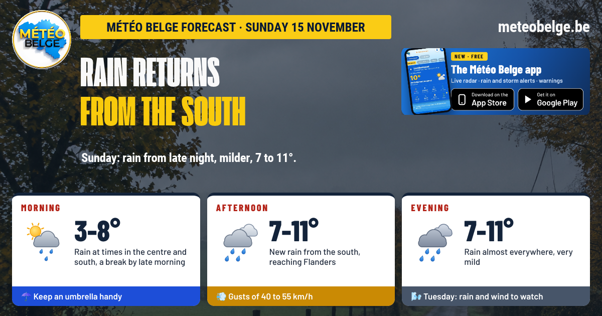
After the coldest night of autumn and a beautiful sunny Saturday, rain returns from the south this Sunday 15 November. A light frost will form again in the early part of the night in the valleys, then a first shower, often light, will move up from late night over the south and centre. After a break late in the morning, fresh rain will spread across the country in the afternoon, reaching Flanders, in noticeably milder air: 7 to 11°C. Tuesday is shaping up to be the day to watch, with heavy rain and fairly strong wind.
- Night: light frost early in the night in the valleys, then light rain from late night in the south and centre, some areas staying dry
- Morning: grey sky, rain at times in the south and centre, a few local clear spells, then a lull towards late morning; fine clear spells on the coast
- Afternoon: more rain from the south, reaching Flanders and the Campine towards the end of the day
- Evening: rain almost everywhere, heavier in the south, very mild
- Temperatures: -2 to 3°C early in the night, 7 to 11°C in the afternoon
- Wind: from the south, gusts of 40 to 55 km/h
- Rain: 2 to 5 mm in the north and centre, 5 to 12 mm in the south, almost nothing on the coast
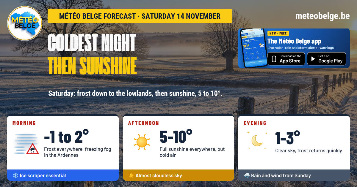
❄️ This Saturday: the coldest night, then clear blue skies
It delivered on its promise: the night from Friday to Saturday was the coldest of autumn, with -1 to -2°C in the early morning in Brussels, Antwerp, Ostend and Charleroi, and locally -3 to -4°C in the countryside, covered in frost. Around Liège, freezing fog proved stubborn, with visibility of barely 150 to 200 metres until mid-morning. Clear blue skies then took over across the country: maximum temperatures reached 9 to 10°C, but only 5°C in the south-east, which sometimes remained shrouded in mist for longer.
🌍 The situation: the anticyclone is moving away, milder weather returns
The anticyclone that gave us this beautiful Saturday is sliding towards Germany. In its wake, a depression is approaching from western France and will direct towards us, from Sunday onwards, a southerly flow that is much milder and more humid. This marks the beginning of a distinctly more unsettled period, with several rainy spells lasting at least until mid-week.
🌧️ Sunday 15 November: rain returns from the south
🌙 This Saturday evening: clear skies and ground frost
Not a cloud disturbs the evening, from the coast to Gaume, in calm air that cools quickly. Frost sets in first over the High Fens, and in the hollows of the Campine, Hesbaye and Entre-Sambre-et-Meuse, the grass turns white with hoarfrost before midnight. Around 21:00-22:00: 0°C on the High Fens, 2°C almost everywhere, 3°C at the coast and in Famenne.
🌌 The night: slight frost, then first drops from the south
Still clear and cold in the early part of the night, the night will see hard frost settle in the valley bottoms, in the Campine and over eastern the Ardennes. Clouds coming from the south will then spread across the sky, with a few patches of fog in the High Fens. Late at night, a first rain band will move up from the south: the Gaume and the Ardennes first, then Hainaut, the Namur region, Brussels, the Liège area, and right through to Limburg and the Antwerp region by early morning. It will be very little, and some places may stay dry. Minima: -2°C in Limburg, 1°C on the coast, in Flanders, in Hainaut, in Charleroi, in the Gaume and over the High Fens, 2°C in Brussels, in the Namur region, in the Liège area and in the Botte du Hainaut, 3°C in Famenne.
🌅 Sunday morning: showers at times, then a quieter spell
The sky will remain grey and low, with rain at times at sunrise over the centre and south, from Hainaut to the Liège region via Brussels and Namur, as well as over the Ardennes, Gaume and Limburg. Some areas will stay dry, and a few temporary bright spells are possible locally. Late morning, the rain will ease almost everywhere, leaving damp greyness. The coast and West Flanders, which have stayed clear, will continue to enjoy fine bright spells. Some patches of fog over the High Fens. At sunrise: 3°C on the coast, 4°C in the Comines region and over the High Fens, 5°C in Flanders, Tournai and the Antwerp region, 6°C in Brussels, Charleroi, the Mons region and the Botte du Hainaut, 7°C in Namur, Famenne and Limburg, 8°C in the Liège region and Gaume.
🌧️ Sunday afternoon: fresh rain spreads across the country
A new band of rain will move up from Gaume, first affecting the south of the Ardennes, then Entre-Sambre-et-Meuse, Condroz, Hainaut and Walloon Brabant in the middle of the afternoon. Flanders and the Campine will follow in the late afternoon, whilst the coast will remain grey but still sheltered, with at most an isolated shower. The heaviest showers will drench the Fagne and the Ardennes, with noticeably milder conditions returning. Highs: 7°C on the High Fens, 10°C on the coast, in the Antwerp region, in Famenne, in the Botte du Hainaut and in Gaume, 11°C everywhere else, from Flanders to the Liège region.
🌙 Sunday evening: rain almost everywhere, very mild
A steady rain will continue almost everywhere, heavier in Gaume, on the Ardennes, in Famenne and in the Campine. Only the coastal strip will largely escape it, with a few drops possible. Rather than dropping, temperatures will remain remarkably mild for the season: 7°C on the High Fens, 9°C in the Botte du Hainaut, 10°C almost everywhere, rising to 11°C in the Liège region.
💨 Wind and rain
The south wind will strengthen throughout the day, with gusts of 40 to 45 km/h on the plains and 50 to 55 km/h on the Ardennes and in the Botte du Hainaut, locally a little stronger on the High Fens peaks in the evening. Regarding rain, we expect 2 to 5 mm in the north and centre, 5 to 12 mm on the Ardennes, the Botte du Hainaut and Gaume, and almost nothing on the coast. These amounts are approximate.
When a depression deepens to the west of France, air rotates around it in an anticlockwise direction. For us, this creates a southerly flow mild and humid air is rising from France and will first reach Gaume et l'the Ardennesbefore moving towards the centre and then Flanders. The Ardennes relief also forces this air to rise, which intensifies rainfall on the high ground. The coast, meanwhile, is the last to be affected, and is sometimes spared.
🌡️ Forecast temperatures on Sunday in the main towns
| Town | Minimum | Maximum | Sky and rain | Gusts (daytime) | Rain (daytime) |
| Brussels | 2°C | 11°C | Light rain at wake-up, more rain in the afternoon | 40 km/h | 2.3 mm |
| Antwerp | 1°C | 10°C | Grey, rain mainly in the evening | 40 km/h | 3.9 mm |
| Ghent | 1°C | 11°C | Bright spells in the morning, light rain in the afternoon | 40 km/h | 2.0 mm |
| Ostend | 1°C | 10°C | Bright spells, then grey, almost dry | 40 km/h | 0.2 mm |
| Liège | 2°C | 11°C | Rain at times, heavier in the evening | 55 km/h | 3.0 mm |
| Namur | 2°C | 11°C | Rain at times, heavier in the afternoon | 45 km/h | 4.2 mm |
| Charleroi | 1°C | 11°C | Rain at times, heavier in the afternoon | 50 km/h | 3.0 mm |
| Mons | 1°C | 11°C | Grey, light rain in the afternoon | 45 km/h | 2.9 mm |
| Tournai | 1°C | 11°C | Grey, light rain in the afternoon | 40 km/h | 3.0 mm |
| Hasselt | -2°C | 11°C | Frost early in the night, then light rain | 45 km/h | 2.7 mm |
| Marche-en-Famenne | 3°C | 10°C | Rain at times, heavier in the evening | 55 km/h | 5.7 mm |
| Virton | 1°C | 10°C | Rain from the night, heavy in the afternoon | 55 km/h | 11.7 mm |
| Butgenbach | 1°C | 7°C | Mist in the morning, rain in the evening | 65 km/h | 5.1 mm |
📅 What's next? Tuesday, the day to watch
Monday 16 November: a calmer spell between two wet spells
Rain and showers throughout the night, then more frequent showers in the morning, especially over the Ardennes, Gaume and the Campine. The afternoon would bring a real lull, with clear spells from Hainaut to Gaume. Fresh rain would arrive from the sea in the evening. South-westerly wind, gusts of 45 to 60 km/h. Lows of 5 to 9°C, highs of 7 to 10°C.
Tuesday 17 November: heavy rain and fairly strong wind
The most unsettled day. Continuous and sometimes heavy rain would affect the whole country, with 15 to 30 mm, or even a bit more over Gaume and the Ardennes. The south-westerly wind would become fairly strong, with gusts of 70 to 85 km/h. It would be very mild, 10 to 14°C. A situation to watch closely.
Wednesday 18 November: more showers and wind
More rain and showers, more persistent over the Ardennes and Gaume, where the ground could become waterlogged. Wind would remain noticeable, with gusts of 55 to 65 km/h. Lows of 6 to 10°C, highs of 8 to 12°C.
| Day | Weather | Temperatures (min / max) | Wind |
| Monday 16 | ⛅ Showers in the morning, a calmer spell in the afternoon, rain in the evening | 5 to 9°C / 7 to 10°C | West to south-west, gusts of 45 to 60 km/h |
| Tuesday 17 | 🌧️ Heavy rain (15 to 30 mm), very mild, to be monitored | 5 to 7°C / 10 to 14°C | South-west, gusts of 70 to 85 km/h |
| Wednesday 18 | 🌬️ Rain and showers, mainly in the south | 6 to 10°C / 8 to 12°C | South-west, gusts of 55 to 65 km/h |
- In the centre and south, keep your umbrella within reach from the moment you wake up
- Late morning will be the best time for a walk or to run errands
- On the coast and in West Flanders, make the most of the morning, which will be the most pleasant
- Use Sunday to tidy up your garden and secure anything that could blow away before Tuesday
Reliability is good for the return of rain and mild weather on Sunday. The first rain towards the end of the night will remain light and sporadic: some places could stay dry until the afternoon. The exact amounts and arrival time of the second wave may still vary by an hour or two. Tuesday remains to be confirmed: heavy rain and fairly strong wind are likely, but their intensity and the regions most affected still need to be confirmed.
What time will the rain arrive at your location? Follow it live on the radar, with hourly forecasts for your town, alerts and weather warnings.
🍏 App Store🤖 Google Play❓ Frequently asked questions
Will it rain on Sunday 15 November?
Yes. Some initial rain, often light, will move up from the south from the end of the night over the south and centre, with a lull towards the end of the morning. Fresh rain will then reach the country during the afternoon, extending into Flanders, and will persist in most places during the evening. The coast will remain the least affected.
What time does the rain arrive?
The first drops will reach Gaume and the Ardennes in the late night, then Hainaut, Namur, Brussels and Liège in the early morning. The second wave will arrive from the south in the early afternoon, in the centre in the mid-afternoon, and in Flanders in the late afternoon.
Will it freeze again on Sunday?
A little, in the early night only: a light frost in valley hollows, in the Campine and on the eastern Ardennes, down to -2°C in Limburg. The air will then warm up noticeably.
What temperature on Sunday afternoon?
7 to 11°C: 7°C on the High Fens, 10 to 11°C almost everywhere else, in air noticeably milder than Saturday.
Should we expect wind on Tuesday?
Tuesday is shaping up to be the most unsettled day, with 15 to 30 mm of rain and gusts of 70 to 85 km/h. These values remain to be confirmed in the coming days.
Forecast issued by Michaël Vincent, Météo Belge.